Aim and Vision
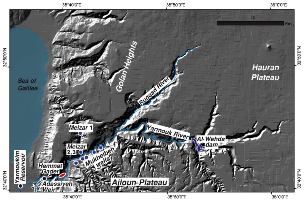
The Yarmouk River is the primary tributary to the Jordan River and a strategic transboundary freshwater resource of Syria, Jordan, and Israel. In the past decades, the Yarmouk watershed has been extensively exploited by the riparian with the construction of dams including the Al-Wehda and Adassiyeh dams, situated along the Jordan border and intended for agricultural purposes. The operation of the dams is guided by international water agreements between Jordan and Israel and Jordan and Syria and control the flux of the Yarmouk River. Preliminary results indicate unexpected interactions of the river with the major groundwater resources of the entire region.
The objectives of this work are hence: (i) to quantify water fluxes and understand flow paths in all groundwater bodies, (ii) their interaction between the groundwater bodies and respectively with the river and (iii) the impact of the anthropogenic control of flow in the Yarmouk River to (iv) suggest operational schemes for flow in the Yarmouk River ensuring long-term safety of the ecological and socioeconomic function of the combined river-groundwater-resource, situated in a difficult transboundary situation.
This will be achieved applying for the first time dating and flow analyses tools in combination with a transboundary network of precise online monitoring stations in the river and aquifers along with numerical modelling of the current state and of possible operational scenarios. Optimization of both dams and groundwater pumping operations has the high potential to increase the stability and availability of freshwater in the area for many years.
.
The overall aim of TransFresh project proposal is the characterization of groundwater and surface water flow and their interaction in the transboundary Yarmouk River Basin to provide all necessary and mechanistically sound information about that system to implement a efficient and transboundary IWRM. To gain that overall goal, we aim to achieve the following specific objectives:
Quantification of anthropogenic controlled water fluxes and investigation of quality-determining flow paths in all groundwater bodies in the Lower Yarmouk Gorge (LYG) and the interaction between these aquifers and the river.
This will be achieved by setting up a tailored monitoring / monitoring concept, which claims to provide all required data in high quality and spatial coverage for the data-driven three-dimensional modelling. The system must be robust and will cope with limited access to the area, security constraints and volatile data transmission possibilities at simultaneously minimum costs and need for maintenance.
Estimation of the water volume exchange due to Yarmouk River‐groundwater interactions.
Suggestions for operational schemes for flow in the Yarmouk River and groundwater abstraction from surrounding aquifers as an example of transboundary water resources management. Knowledge-based enhancement of cooperation between riparian water suppliers as key element for smart management of transboundary water resources.
The project outcomes will hence improve our knowledge about the complex groundwater-surface water system of the Lower Yarmouk Gorge, which is the fundamental base for a comprehensive water resources management, which is urgently needed to protect both, the vital groundwater resources and the Yarmouk flow to ensure drinking water supply for large areas of NW Jordan, farmland irrigation in Israel and Jordan, the ecology of the whole Lower Jordan Valley and the extremely vulnerable Dead Sea region by keeping the Lower Jordan River running.
At the same time the project will provide an exploitable methodology: the recipe for an efficient and transferable transboundary water resources monitoring/modelling system, which is able to overcome the typical obstacles of such a region by providing all required data for a mechanistic understanding and a complex resource model at minimum costs.
Work packages:
WP1 Project coordination and management (H3): WP1 has the objectives to ensure an efficient and smooth coordination of the scientific and technical activities as well as the overall administration of the project and to support the different teams in their cooperation and execution of project work. In addition, the project coordination takes care about the communication with the stakeholder board (SB).
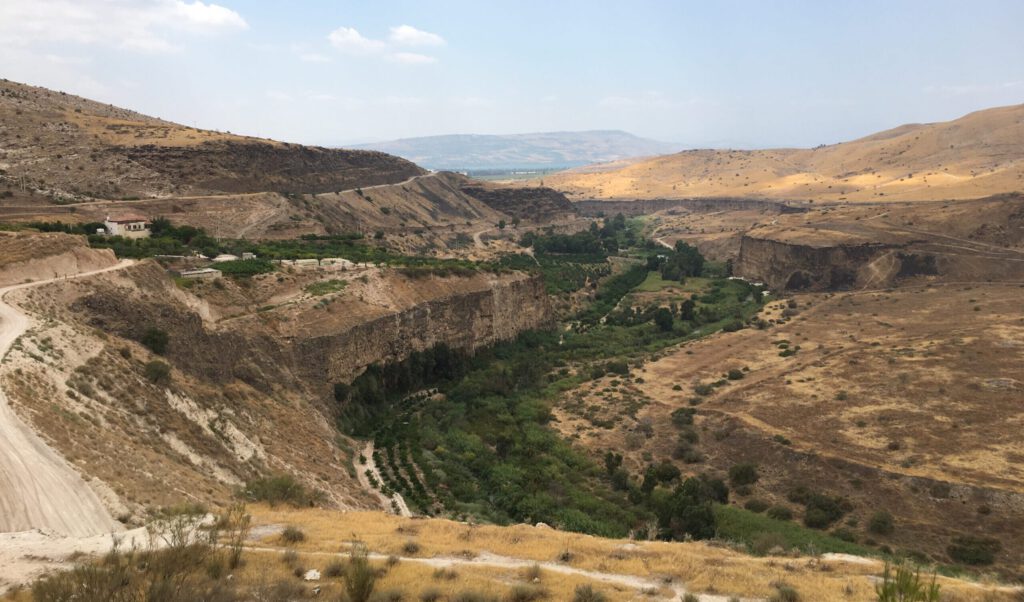
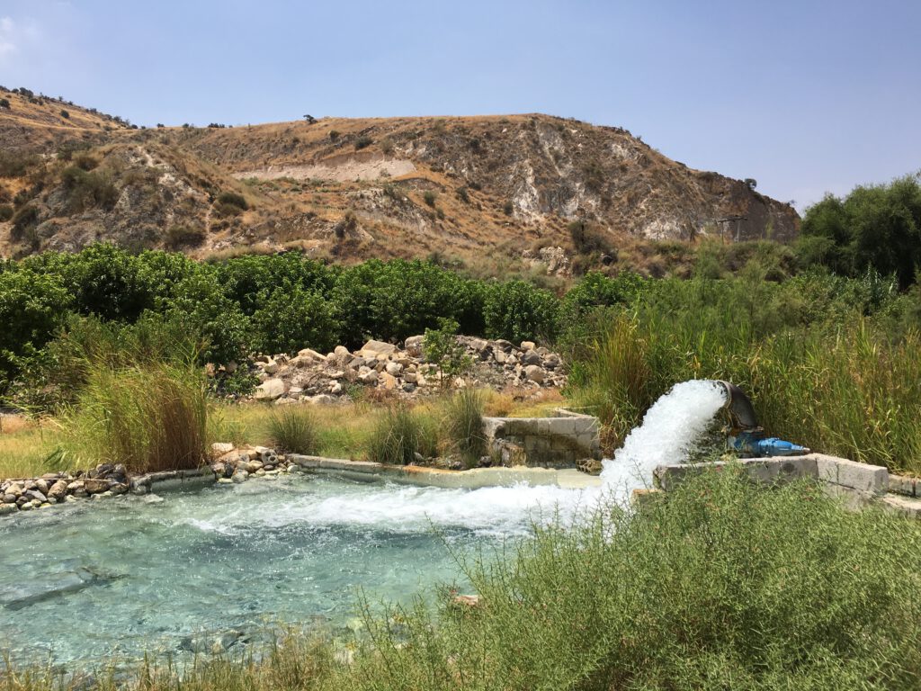
WP2 Data management and monitoring (H3, GSI, NARC): Within the Lower Yarmouk Gorge (LYG), Siebert et al. (2014; 2019) were able to identify several types of groundwater that appear, interact somewhere and seem to be in bidirectional contact with the Yarmouk river. However, reliable data to reveal the dynamic interactions of these surface and groundwater resources and their individual reaction on recharge events are missing and urgently needed. Hence, we conceptualized a continuous and automatic monitoring system of water flux, temperatures and in situ parameters (T, pH, EC) and will realize it within that working package.
WP3 Hydrogeochemical water body characterization (H3, NARC, GSI): Within that work package, hydrochemical and stable/radio isotope samples will be taken to receive efficient indicators for changing hydraulic conditions in the three proposed groundwater systems. Isotopic and trace element sampling will be conducted to precisely analyse the dynamic interaction and residence times of groundwaters from the different groundwater bodies and different recharge areas (Mt. Hermon, Hauran, Ajloun), which variably mix with ascending and old saline water.
WP4 Modelling the river – aquifer system (GSI, H3, NARC): We have modelled the groundwater system in the Yarmouk basin in 2D in the past (e.g. Roded et al. 2013; Rödiger et al. 2014, Magri et al. 2016; Rödiger et al. 2017, Tzoufka et al. 2018). In this work, we propose to include the coupling of the Yarmouk River with groundwater and to set up a full 3D model. Coupling between the river and groundwater will be performed using interactive data-based boundary conditions. The role of the river as gaining or losing stream will be determined in the model.